Marine Nature Map
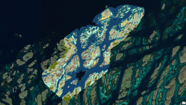
The project delivers a national, wall-to-wall map of NiN 3.0 main marine benthic ecosystem types for Norway’s coastal and marine area out to 1 nautical mile from the baseline, accompanied by probability/uncertainty maps. The workflow integrates remote sensing (drone, satellite, bathymetric LiDAR), niche modelling, and existing reference datasets.

- Project period
- -
- Funders
- Norwegian Environment Agency (Miljødirektoratet)
- Total budget (NOK)
- 15,000,000
- Research section
- Marine biology
- Contact persons
-
 Hege Gundersen
- Involved from NIVA
-
 Dag Øystein Hjermann
-
 James Edward Sample
-
 Kasper Hancke
-
 Eli Rinde
-
 Paul Ragnar Berg
About the project
Marine Nature Map underpins spatial planning and ecosystem/natural capital accounting. In 2025 the team develops prototype models and pilot maps using drone‑derived habitat maps (SeaBee) and Sentinel‑2 based upscaling; in 2026 we add targeted field reference data, upscale nationwide, and stitch shallow (remote sensing) and deeper‑water (niche modelling) outputs into a seamless national product by 1 December 2026. Deliverables follow open standards (GeoPackage, EPSG:25833) with a full technical report, code, models and metadata (GitHub). Partners include Norwegian Computing Center (NR) for ML/AI and Field Geospatial for satellite/GEOML and bathymetric LiDAR.
Partners (subcontractors):
• Norwegian Computing Center (NR) – AI/ML for drone and satellite-based classification
• Field Geospatial – satellite-based mapping, bathymetric LiDAR, GEOML platform